Each month, the Historical Society of West Windsor—a nonprofit that preserves and promotes local history—publishes a column covering our town’s rich heritage.
This article explores the history of West Windsor’s roads and is also an excerpt from our recently-released West Windsor History Book, which covers our town’s story from the prehistoric era to the present day. Visit westwindsorhistory.com/book to learn more.
Also—2022 is West Windsor’s 225th birthday! The Historical Society is leading dozens of commemorative community projects and free-to-the-public events throughout the year. Visit westwindsorhistory.com/year-225 to learn more.
A Revolutionary March
In the early morning of January 3, 1777, an army marched through present-day West Windsor. The Revolutionary War was in full swing, and George Washington and his soldiers had left Trenton several hours prior—where they had emerged victorious after two consecutive battles there in the span of just over a week. The troops trudged through mud and ice on their way to what would be the Battle of Princeton later that day. Their victory there would be their third ray of hope in what were previously the darkest hours of the war. The route the revolutionaries took included the “Quaker Bridge” Road—an avenue built many years prior to connect the old Stony Brook Quaker meeting house in present-day Princeton (next to the Princeton Battlefield) to another Quaker meeting house in the village of Crosswicks, Chesterfield Township. Thousands of soldiers marched along this road—now constituting most of the border between West Windsor and Lawrence Townships – to legendary victory.
However, the story of West Windsor’s transportation systems is even older than the American Revolution. Let’s travel back in time to the era of the area’s indigenous inhabitants.
Footpaths
Long before any colonist set foot in New Jersey, the footpaths of our indigenous predecessors – the “Lëni Lënape” – meandered through its meadows and forests, forming a network stretching across their territory. The most relevant of these paths to us was the “Assunpink Trail,” which ran from Trenton to north of the Raritan River. A first-hand description appears in the 1679 journal of Jasper Danckaerts, a Dutch agent who had come to the New World to purchase land for a colony of fellow Labadist Protestants:
“The road from here [the Raritan River near New Brunswick] to the Falls of the South River [Trenton, on the Delaware River] … is nothing but a foot-path for both men and horses between the trees and through small shrubs … we came to places where there were large plains, beset with few trees, and grown over with long grass, which was not the worst.”
Despite this description, the Assunpink Trail was a major artery for the Lënape and early colonists. Moreover, this image of an overgrown, narrow path was not unique to the Lënape’s trails—later colonial roads were often equally as small and often ill-maintained. Like its counterparts in New Jersey, the Assunpink Trail gradually disappeared over the decades, being developed into colonial roads that approximated its former route. Over the years, these replacements were known collectively as the “Old Dutch Trail,” the “King’s Highway,” “Lincoln Highway,” and modern Routes 27/206.
Colonial Roads
Early governments delegated responsibility of road planning and construction to individual counties and townships. “Commissioners for Laying Roads” were tasked with establishing avenues and “Overseers of the Highways” were responsible for their maintenance. Both offices required significant funds and labor.
Two classes of roads existed in colonial New Jersey: major avenues that linked well-populated towns and required significant planning, and local roads that were often informally established, primitive, and poorly maintained. These latter routes often meandered through farmland, zigzagging through the landscape to connect individual residences rather than following more direct routes between towns. Seasonal conditions frequently restricted travel and water routes were often preferred. Even sleds were used on frozen rivers decades before stagecoach travel became popular in the mid-18th century.
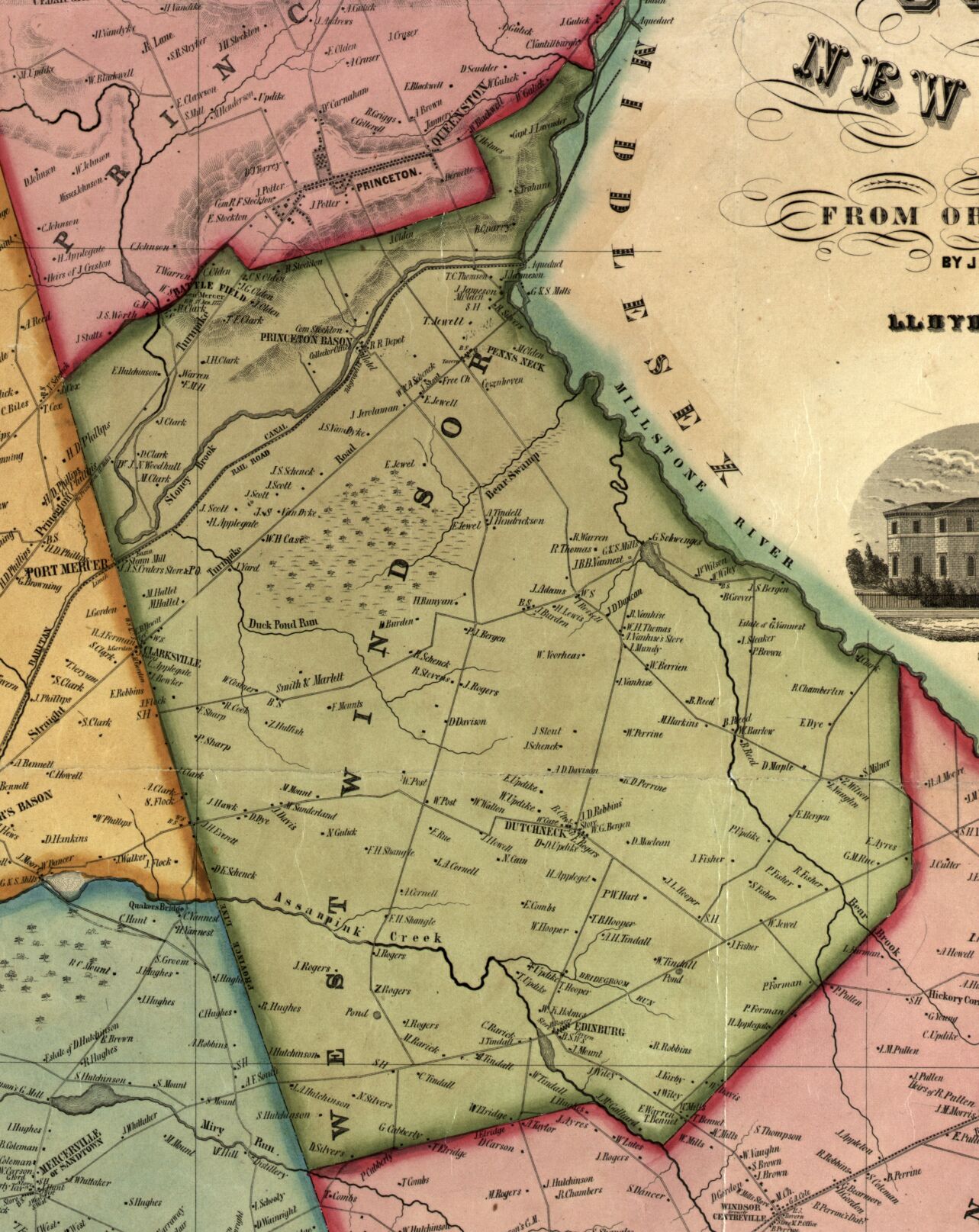
West Windsor’s early road system developed during its first large wave of settlement in the mid-1700s. Those with 18th-century documentation (some stretching back to the mid-1740s) include Clarksville, Edinburg, Robbinsville-Edinburg, Line, South Mill, Windsor, Cranbury, Southfield, Princeton-Hightstown, Rabbit Hill, North Mill, and Quakerbridge Roads, as well as South Lane, Village Roads East/West, and Lower Harrison Street. Even more crisscrossed the area but have long disappeared.
Many of West Windsor’s earliest roads were named after the communities they connected or property lines. We’ve already mentioned Quakerbridge Road linking two Quaker settlements. As early as 1744, the “Princeton-Hightstown” road stretched from Hightstown to at least as far as David Lyell’s “Great Tract” in present-day West Windsor, presumably to connect inhabitants to the “Old York Road” that provided access to larger cities in New Jersey. It was later extended to Princeton. The “Clarksville-Grovers Mill” road (now just “Clarksville Road” connected its named communities, as did the “Dutch Neck-Edinburg Road” (now just “Edinburg Road”).
Two of the first roads constructed after West Windsor’s 1797 formation are still in use. The current alignment of Old Trenton Road, which runs through the community of Edinburg and historically linked Cranbury to Trenton, developed c. 1803 as a straightening of older, likely colonial avenues. The following year, the “Trenton-New Brunswick Turnpike” (now Brunswick Pike, part of the Route 1 interstate) was chartered, cutting a course through much of New Jersey. This road deserves special mention as a demonstration of how much West Windsor has developed: while we know of Route 1 today as a busy, multi-lane highway, back in the early 1800s it, too, was a narrow, often rutted and pothole-filled dirt farm lane. In fact, for many years, the highway was known as the worst in the state and West Windsor was sued at one point for failing to maintain it. Still, the Turnpike’s access to two of New Jersey’s larger cities made it well worth the upkeep.
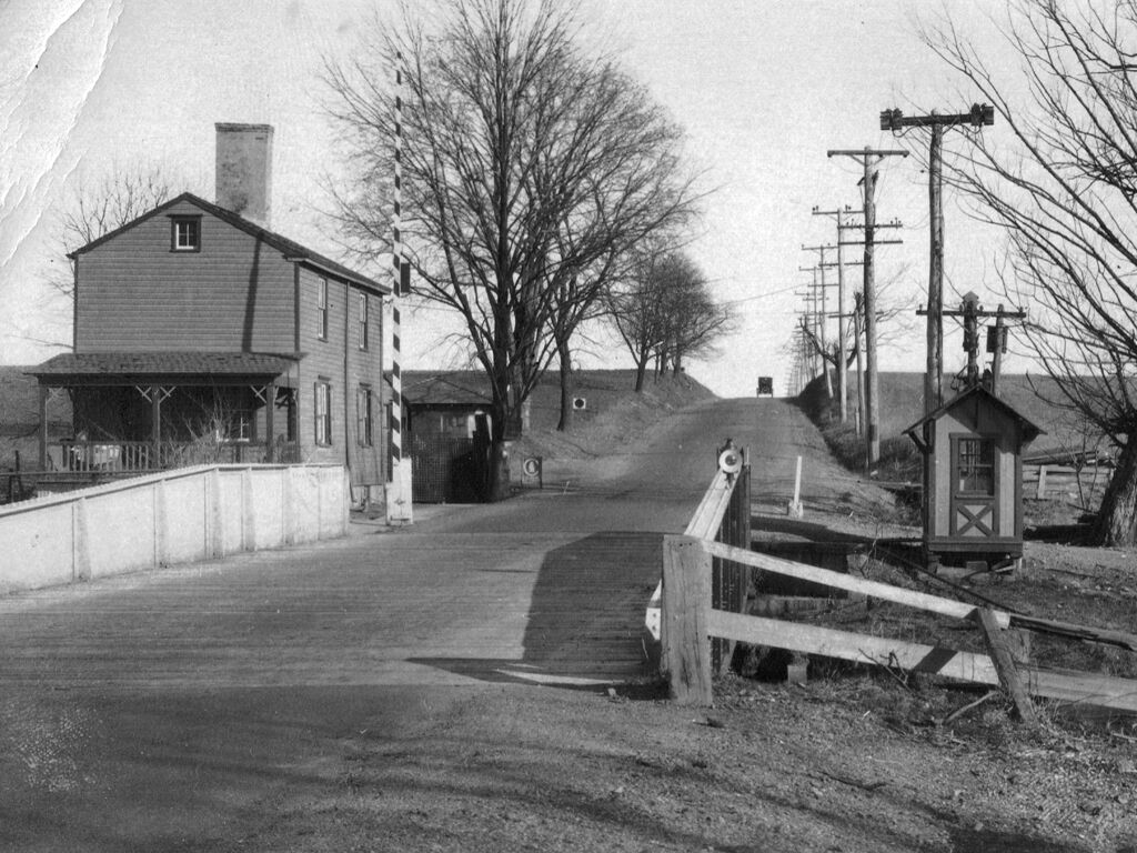
Several historic local villages – such as Penns Neck, Dutch Neck, Edinburg, Clarksville, and VanHiseville – flourished as crossroad communities. They featured stores, taverns, wheelwright shops, and other establishments often catering to stagecoach travel.
19th Century development
Throughout the 1800s, about a dozen more avenues began to cut through West Windsor. Many of these “new” roads were named after locals and landscapes. North and South Post Roads (1833 and 1835) converge where William Post’s old white house still sits off Village Road West.
North Post Road was also once known as “Tatamy’s Swamp Road,” presumably after a local Lëni Lënape leader named Moses Tunda Tatamy and his land. Meadow Road (c. 1855) was originally called “Bear Swamp Road” for the wetlands it traversed. And Penn-Lyle Road (c. 1866/7) followed a 1690s-era old division line that once separated the immense properties of two of the area’s original colonial landowners: William Penn (founder of Pennsylvania) and David Lyell (an English goldsmith).
Twentieth Century and Beyond
Until the turn of the 20th century, local roads were dirt farm lanes. But the turn of the twentieth century brought new developments, including the laying of “macadam” (asphalt) to accommodate motorized travel.
Amid the post-World War II national suburban “boom,” West Windsor began to transform from farmland to suburbia. New housing and commercial developments—especially in the last quarter of the 20th century—necessitated many new roads. Over the decades, many routes were widened—most notably Route 1, which, once surrounded by farmland, now cuts through an endless commercial landscape.
Today, a network of hundreds of roads crisscrosses the township, upon which traffic sometimes zooms by, and at other times, seems to be in an endless standstill. Despite this flux, however, there is a constant: that dozens of the old avenues from the 1800s and 1700s remain as memorials to centuries past.
To contact, support, or volunteer for the Historical Society, visit westwindsorhistory.com. We are also on social media—search “@SchenckFarmstead” on Facebook and Instagram. Email us at westwindsorhistory@gmail.com.